|
United States History and Geography:
Making a New
Nation
Harcourt School Social Studies Website

How to Organize a State Report
5.4 California State Standard--Social Studies

Students understand the political, religious, social, and economic
institutions that evolved in the colonial era.
|
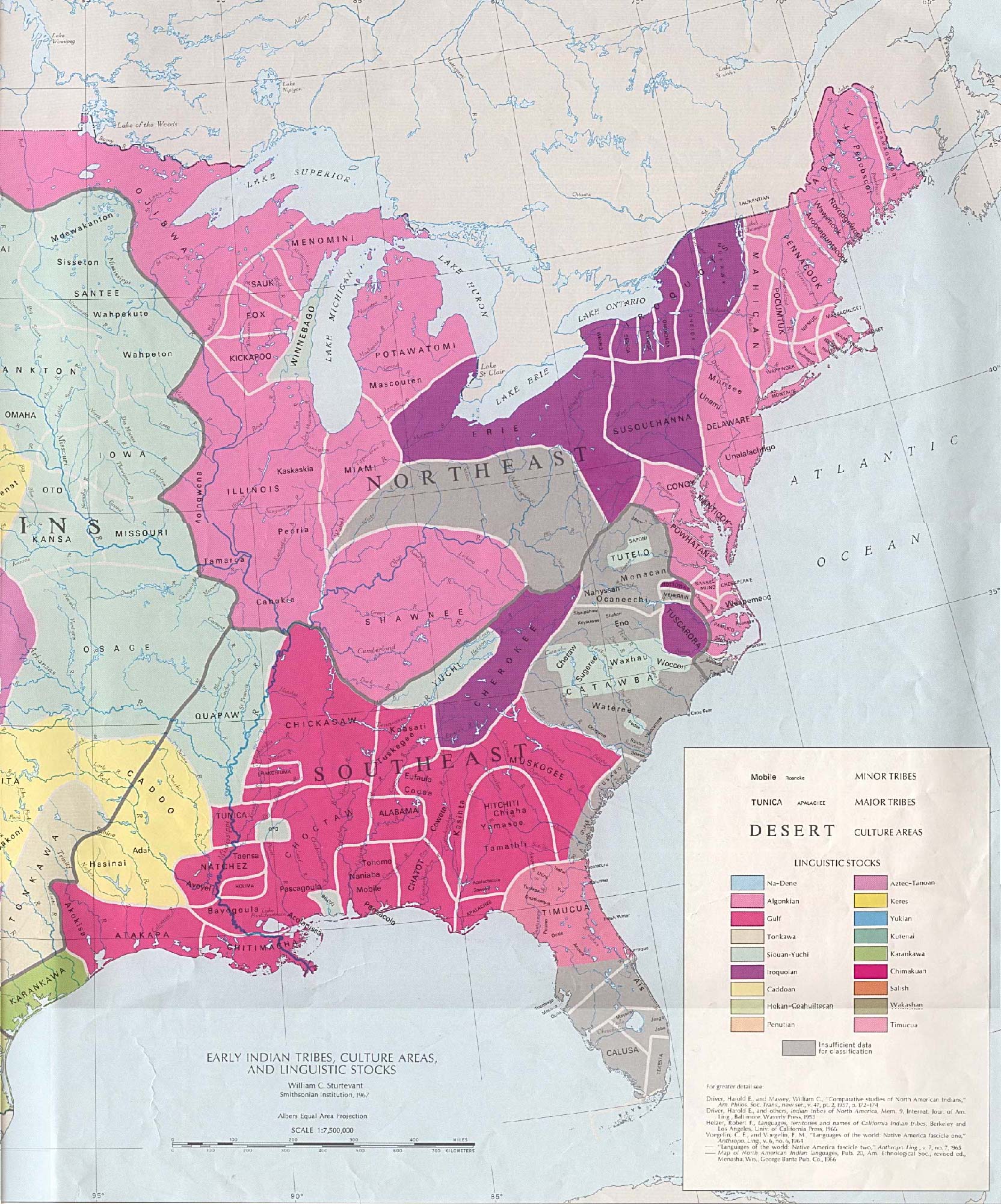
Understand the influence of location and physical
setting on the founding of the original 13 colonies, and identify on a map the locations of the colonies
and of the American Indian nations already inhabiting these areas.
|
Identify the major individuals and groups responsible
for the founding of the various colonies and the reasons for their founding
(e.g., John Smith, Virginia; Roger Williams, Rhode Island; William
Penn, Pennsylvania; Lord Baltimore, Maryland; William Bradford, Plymouth; John Winthrop, Massachusetts).
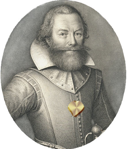
Captain John Smith
More People of the American Revolution:
http://darter.ocps.net/classroom/revolution/index.html#people
|
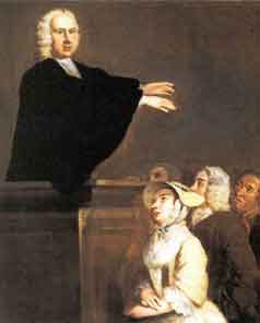
Describe the religious aspects of the earliest colonies
(e.g., Puritanism in Massachusetts, Anglicanism in Virginia, Catholicism
in Maryland, Quakerism in Pennsylvania).

|
Identify the significance and leaders of the First
Great Awakening, which marked a shift in religious ideas, practices, and allegiances in the colonial period, the growth of
religious toleration, and free exercise of religion.
|
Understand how the British colonial period created
the basis for the development of political self-government and a free-market economic system and the differences between the
British, Spanish, and French colonial systems.

|
|
Describe the introduction of slavery into
America, the responses of slave families to their condition, the ongoing struggle between proponents and opponents of slavery,
and the gradual institutionalization of slavery in the South.

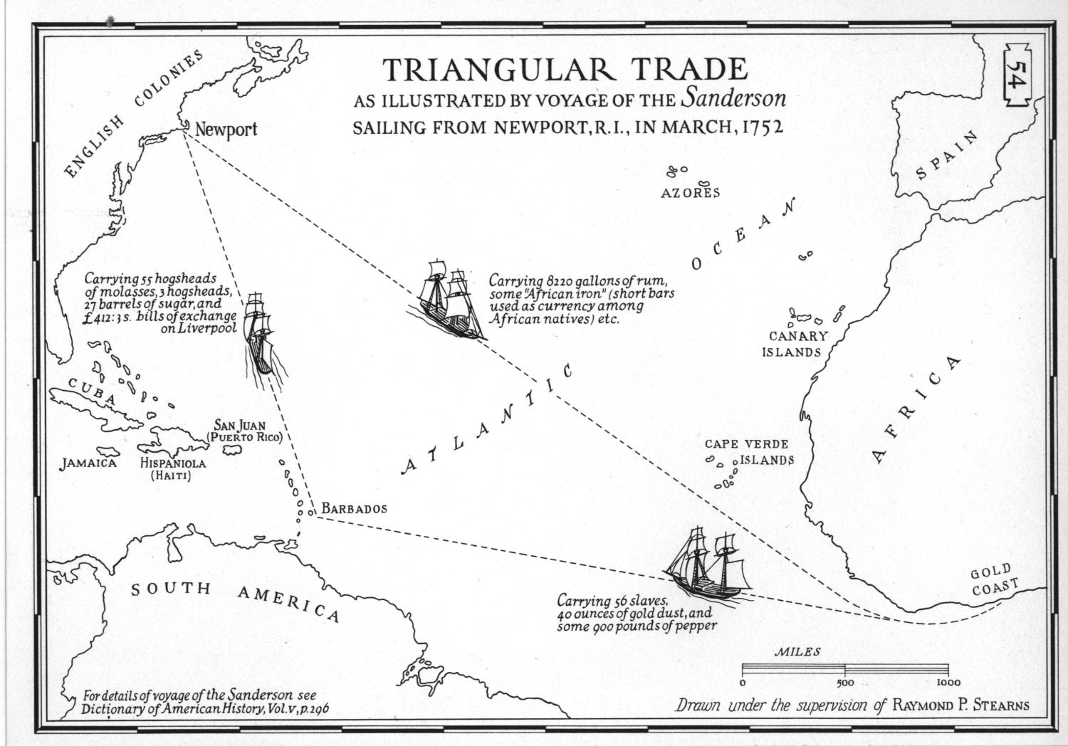
Triangular Trade
From the 1600s to 1800s, large sailing ships, owned by British businessmen, set sail from England en route to
the west coast of Africa. There, kidnapped Africans, taken from their villages and families, were forced into extremely overcrowded
quarters in the ships and sailed to the Caribbean, North America, and South America – a journey that took from five
to twelve weeks. If you look at a map, you can see how this forms a triangle. Between 30 and 60 million Africans made the
trip from Africa to America in this way, many of them dying during from the long journey and horrible conditions.
OBJECTIVES
Students will:
work together in small groups to find data and information about the
seventeenth and eighteenth century slave trade,
identify a popular triangular trade route and the distance from
one port to another on a world, map
further understand the harsh and inhumane treatment of Africans
during this time period.
Teacher: Print World Map
To complete this lesson you will need:
-
Your Social Studies book, pp.226-227
-
colored pencils or crayons
-
pencil
-
Note Taking sheet (click to print below)
1. Watch the BrainPop on Slavery (You'll have to log in)
2. Read pp. 226-227 in your Social Studies book.
3. Take notes on what you are reading and seeing
on the Note Taking sheet.
4. Describe Triangular Trade, the Middle Passage, Slaves in Africa, and Slave Auctions
on your project booklet.
More Links:
Slavery in the Colonies
Triangular Trade: Social Studies for Kids
|
Explain the early democratic ideas and practices
that emerged during the colonial period, including the significance of representative assemblies and town meetings.

|
|
Chart of the Thirteen Original Colonies
|
For more information about the original thirteen colonies and colonial life
check out these resources. |
United
States History and Geography: Making a New Nation
Lewis and Clark
|
 |
|
Did You Know?
For 200 years, the Expedition journals have been the source for
knowledge and understanding of the Corps of Discovery. There are, however, more than 50 tribes whose oral histories also record
the events and people of the Corps. |
|
 |
|
Did You Know?
Jefferson sent the Corps of Discovery to find the "most direct &
practicable water communication across [the] continent." Although the Corps did not find the water route Jefferson had hoped
for, they did explore 4 major rivers: the Missouri, the Columbia, the Snake, and the Yellowstone. | |
|
 |
|
Did You Know?
Two hundred years after the Lewis and Clark Expedition, the only
physical evidence of the journey is found near Billings, MT. In July 1805, William Clark carved his name into the soft rock
of what he called Pompeys Tower. This site is now preserved at Pompeys Pillar National Monument. |
|
 |
|
Did You Know?
Jefferson expected the Expedition to learn about the people, plants
and animals of the newly acquired Louisiana Purchase. None of the men of the Expedition was a trained scientist, but fulfilling
Jefferson’s instructions required skills in cartography, ethnography, botany, zoology, and meteorology.
|
|
 |
|
Did You Know?
The Lewis and Clark Expedition was to record "the names of the nations
& their numbers.” Interactions with American Indians were, however, more than a record of names and numbers. They
were matters of survival and success. Trade with tribes and the information they provided sustained the Expedition. |
Going West
Play the game

California State Standards:
5.8 Students trace the colonization, immigration,
and settlement patterns of the American people from 1789 to the mid-1800s, with emphasis on the role of economic incentives,
effects of the physical and political geography, and transportation systems.
1. Discuss the waves of immigrants from Europe between 1789 and 1850 and their
modes of transportation into the Ohio and Mississippi Valleys and through the Cumberland Gap (e.g., overland wagons, canals,
flatboats, steamboats).
2. Name the states and territories that existed in 1850 and identify
their locations and major geographical features (e.g., mountain ranges, principal rivers, dominant plant regions).
3. Demonstrate knowledge of the explorations of the trans-Mississippi West
following the Louisiana Purchase (e.g., Meriwether Lewis and William Clark, Zebulon Pike, John Fremont).
4. Discuss the experiences of settlers on the overland trails to the
West (e.g., location of the routes; purpose of the journeys; the influence of the terrain, rivers, vegetation, and climate;
life in the territories at the end of these trails).
5. Describe the continued migration of Mexican settlers into Mexican
territories of the West and Southwest.
6. Relate how and when California, Texas, Oregon, and other western
lands became part of the United States, including the significance of the Texas War for Independence and the Mexican-American
War.
5.9 Students know the location of the current 50 states and the names
of their capitals.
3. Demonstrate knowledge of the explorations of the trans-Mississippi
West following the Louisiana Purchase (e.g., Meriwether Lewis and William Clark, Zebulon Pike, John Fremont).
A map of Lewis and Clark's Route
Interactive Trail Map
Play the game
Black Tailed Prairie Dog
4. Discuss the experiences of settlers on
the overland trails to the West (e.g., location of the routes; purpose of the journeys; the influence of the terrain, rivers,
vegetation, and climate; life in the territories at the end of these trails).
Bison (buffalo)

Imagine...
When Europeans came to today's America, they encountered diverse peoples in what was to them a New World.
Hundreds of cultures existed in these lands. People spoke many different languages and dialects; governed themselves
differently; lived in many kinds of homes; and had diverse ways to worship, to celebrate, to mourn, and to care for one another.
The Europeans had a difficult time understanding this way of life and considered all of these people the
same. They put all of the native people into one category: Indians.
Courtesy Huntington Library: Legacy and Legend
We will explore these people, the regions they lived in, their culture and beliefs.
California State Social Studies Standards--5th Grade:
NATIVE AMERICANS
5.1 Students describe the major pre-Columbian settlements, including the cliff dwellers and pueblo people of the desert
Southwest, the American Indians of the Pacific Northwest, the nomadic nations of the Great Plains, and the woodland peoples
east of the Mississippi River.

The First Natives
This is a great website with numerous resources from the Clovis Unified School District
Read Sagoyewatha's Speeches
|
|
|
|
|
PACIFIC NORTHWEST INDIANS
Pacific Northwest Indian: Images
THE PLAINS INDIANS: Moving From Place to Place
STANDARDS BASED ACTIVITY:
Native American Poster Directions
You
will be working in a group to create a poster about Native Americans. Each person
in the group will take on a different "job". Your poster must include the following:
q A map of the U. S.
colored in where your tribe lived
q a picture of the kind of dwelling in which they lived
q how they obtained food
q their clothing
q tools they used
q customs and traditions
q how they governed themselves (what rules and laws did
they have?)
Include a description
below each picture with at least four to five details. DO NOT CUT AND PASTE YOUR DESCRIPTION
FROM THE INTERNET. Read the description on the website and then re-write it in your own words (paraphrase).
You will be able to find this information in the packet from Mrs. Hutter
and on the internet sites below.
Have fun and be creative! We will be presenting our posters to the class.
: 
EXPLORERS HALL OF FAME: http://library.thinkquest.org/4034/hall_of_fame.html
Explorer Links:
CALIFORNIA STATE STANDARD
5.9 Students know the location of the current 50 states and the names of their capitals.
The Fifty
Nifty United States:
State Govenors:
http://www.usa.gov/Contact/Governors.shtml
|


